Chicago, known for its stunning skyline, vibrant neighborhoods, and rich history, is a city that thrives on movement. Whether you’re a tourist exploring the attractions or a local commuting to work, understanding the city’s public transit system can greatly enhance your experience. This article will provide a comprehensive guide to navigating Chicago’s public transit, covering everything from the different transit options available, tips for using them efficiently, fare information, and personal experiences to help you make the most of your travels in the Windy City.
Chicago’s Public Transit System
Chicago boasts one of the most extensive public transportation systems in the United States, primarily managed by the Chicago Transit Authority (CTA). The CTA operates a network that includes buses and the famous “L” trains, which are elevated trains that connect various parts of the city and some suburbs. Additionally, there are regional rail services offered by Metra and Pace buses serving suburban areas.
1. The “L” Train System
The Chicago “L” (short for “elevated”) is a rapid transit system that consists of eight lines, identified by colors and letters. The lines are:
- Red Line: Running north-south, it connects the Howard terminal on the north side to the 95th/Dan Ryan terminal on the south side. Major stops include downtown and near attractions like Wrigley Field and the United Center.
- Blue Line: This line runs from O’Hare International Airport to Forest Park. It’s particularly convenient for travelers heading to and from the airport.
- Green Line: Connecting Ashland to the Loop, this line services several neighborhoods and is a great option for those heading to the West Side.
- Brown Line: This line runs from Kimball to the Loop and is known for its scenic route through Lincoln Park and Lakeview.
- Pink Line: Connecting Polk to 18th, this line primarily serves the Near West Side and Pilsen neighborhood.
- Orange Line: This line connects Midway International Airport to the Loop, making it ideal for travelers.
- Yellow Line: A shorter line running from Dempster-Skokie to Howard, it serves the northern suburbs.
- Purple Line: It operates from Linden to Howard and primarily serves Evanston.
The “L” is an iconic feature of the Chicago skyline and offers a reliable and efficient way to navigate the city.
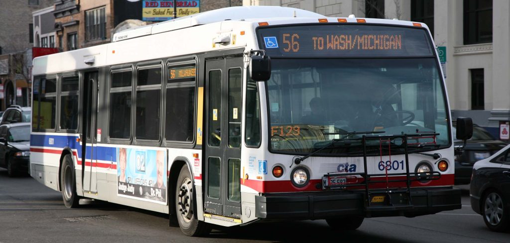
2. CTA Buses
The CTA operates over 100 bus routes throughout Chicago, providing extensive coverage to neighborhoods that the “L” does not reach. Buses are an excellent option for traveling short distances or reaching areas not served by the train system. They run frequently throughout the day, and many routes operate 24/7.
3. Metra and Pace
- Metra: This regional rail service connects Chicago with its suburbs, making it an essential option for commuters. It operates several lines that link the city to areas as far away as Aurora, Elgin, and Joliet. The Metra trains are particularly useful for those who work in Chicago but live outside the city.
- Pace: This bus service connects suburban areas and provides a vital link to the CTA system. If you’re heading to the suburbs or exploring areas beyond Chicago, Pace is a good option.
Getting Started: Planning Your Trip
Navigating Chicago’s public transit system can seem overwhelming at first, but with a little planning, it can be straightforward. Here are some essential steps to consider before starting your journey:
1. Download Transit Apps
Several mobile apps can assist you in navigating Chicago’s public transit system, including:
- CTA Train Tracker: This app provides real-time arrival information for “L” trains and can help you plan your route effectively.
- Transit App: This comprehensive app covers CTA buses, Metra, and Pace services, offering real-time tracking, maps, and trip planning features.
- Google Maps: Google Maps offers public transit directions and schedules, making it easy to plan your journey in real time.
2. Understand the System Map
Familiarize yourself with the CTA system map, which outlines the train and bus routes, major stops, and connections. The map is available online and in transit stations, making it easy to plan your trip.
3. Choose Your Route
Decide on your starting point and destination, then check the best routes using your preferred transit app or the CTA website. Consider factors such as travel time, transfers, and accessibility when selecting your route.
Fare Information
Understanding the fare system is crucial for navigating Chicago’s public transit efficiently. Here’s what you need to know about purchasing tickets and passes:
1. Fare Structure
The CTA employs a zone-based fare structure. Here’s a breakdown of the current fare options (as of 2024):
- Single Ride Ticket: $3.00 (valid for 2 hours)
- 7-Day Pass: $28.00 (unlimited rides for seven consecutive days)
- 30-Day Pass: $105.00 (unlimited rides for thirty consecutive days)
Buses and trains use the same fare system, and transfers between them are allowed within the 2-hour window with a single fare.
2. Purchasing Tickets
You can purchase tickets at vending machines located at “L” stations, online through the CTA website, or via the Ventra mobile app. Ventra is the CTA’s payment system and provides a contactless option for fare payment.
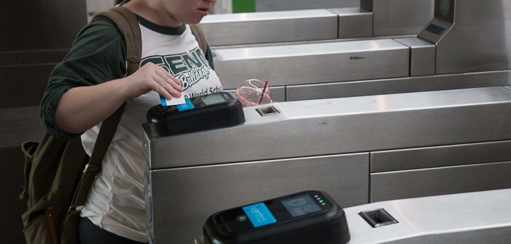
3. Using the Ventra Card
The Ventra Card is a reloadable transit card that can be used on both buses and trains. Here’s how to use it:
- Purchase: Get a Ventra Card from a vending machine or the Ventra website.
- Load Funds: Add value to your card at vending machines or through the mobile app.
- Tap In: Simply tap your card on the reader at the “L” station or on the bus to pay your fare.
Using a Ventra Card is often more convenient than purchasing individual tickets, especially for frequent riders.
Tips for Using Public Transit
- Safety First: Chicago is generally safe, but it’s always best to stay aware of your surroundings, especially at night. Keep personal belongings secure and avoid displaying valuables.
- Check Real-Time Schedules: Use apps like CTA Train Tracker or Transit App to check real-time arrivals and departures. This can help you minimize waiting time and plan your journey more efficiently.
- Know the Peak Hours: Rush hours typically occur from 7-9 AM and 4-6 PM on weekdays. If possible, avoid traveling during these times to sidestep overcrowded trains and buses.
- Respect Transit Etiquette: Be courteous to fellow passengers. Give up your seat to those in need, keep conversations at a reasonable volume, and avoid blocking the aisles.
- Transfer Wisely: If your trip requires multiple transfers, plan accordingly. Allow extra time for transfers between buses and trains, especially during peak hours.
Personal Experiences with Public Transit in Chicago
As a frequent visitor and occasional commuter in Chicago, I have experienced both the advantages and challenges of using public transit. One memorable trip involved visiting the Art Institute of Chicago. Starting from the Loop, I hopped on the Red Line and found it to be a quick and direct route. The train was crowded, but the energy of fellow commuters made the experience enjoyable.
After my visit to the museum, I decided to explore the city further. I used the Transit App to find the best bus route to the Millennium Park, which was only a few blocks away. The app provided real-time updates, allowing me to plan my journey efficiently. I appreciated how the CTA buses were clean and well-maintained, and the drivers were friendly and helpful.
However, I also encountered challenges during peak travel times. Once, I took the Blue Line to O’Hare during rush hour, and the train was packed. While I expected some crowding, the experience reminded me to plan my travels wisely and consider alternative routes or times.
Navigating Chicago’s public transit system is a rewarding experience that allows you to explore the city like a local. With a variety of options, including the “L” trains, buses, and regional services, getting around has never been easier. By understanding the fare system, utilizing transit apps, and respecting etiquette, you can make the most of your public transit journey.